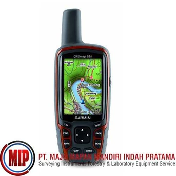
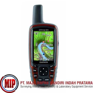
Detail GARMIN GPS 62S GPS MAPPING
These rugged handhelds feature a 2.6” sunlight-readable 65K color screen that supports BirdsEye™ Satellite imagery that lets you download satellite images to your device and integrate them with your maps ( subscription required) and Custom Maps. Waterproof, the GPSMAP 62 Series features a quad helix antenna for unparalleled reception and sleek new design. Other features include built-in worldwide basemap with shaded relief, so you can navigate anywhere with ease, photo navigation, and you can easily add more maps with Garmin' s wide array of detailed topographic, marine and road maps.
With 1.7G of onboard memory, you can conveniently download 24K and 100K topo maps and hit the trail, download BlueChart® g2 for a great day on the water or City Navigator NT® map data for turn-by-turn routing on roads ( see maps tab for compatible maps) . With a simple connection to your computer and to the Internet, you can get a detailed analysis of your activities and send tracks to your outdoor device using Garmin Connect™ . This one-stop site offers an activity table and allows you to view your activities on a map using Google™ Earth.
GPSMAP® 62s Includes a 3-axis tilt-compensated compass, a barometric altimeter and supports Custom Maps and photo navigation. Wireless sharing is also possible among friends with similar units. Receiver Channels: 12. GPS Antenna: High Sensitivity, Quad Helix. WAAS Capable: Yes. Acquisition Time: 0: 15 - 0: 45. Accuracy: ± 15m. DGPS: < 3m. Waterproof Standard: IPX7. Unit Size ( HWD) : 2.4" x 6.3" x 1.4" . Unit Weight: 9.2 oz. Display Type: Transflective, 65K color TFT. Display Size: 1.6" x 2.2" . Battery: 2 ” AA” batteries ( not included) . Battery Life: 20 hours. Internal Memory: 1.7 GB. Expandability: Micro SD. Interface: USB and NMEA 0183. Waypoints: 2, 000. Tracklog Points: 10, 000 points. Routes/ Legs: 200. Basemap: Worldwide. Map Storage: Expandable. Topographic Maps: Mapsource Topo. Marine Maps: Mapsource BlueChart. Area Calculation: Yes. Electronic Compass: Yes. Barometer/ Altimeter: Yes. Calendar: Yes. Audible Alarms: Anchor, Arrival, Clock, Offcourse. Elevation/ Vertical Speed: Yes. Celestial Information: Yes.
Tampilkan Lebih Banyak