Detail GARMIN GPS 78S GPS MAPPING
Ideal for use around water, the GPSMAP 78 Series is IPX7 waterproof and even floats! With the high-sensitivity, WAAS-enabled GPS receiver and HotFix™ satellite prediction, GPSMAP 78 Series locates your position quickly and precisely and maintains its GPS location even in heavy cover and deep canyons. Adding more maps is easy with the microSD card slot which is located inside the waterproof battery compartment, so you don' t have to worry about getting it wet. In addition, the GPSMAP 78 Series supports geocaching GPX files for downloading geocaches and details straight to your unit. They store and display key information, including location, terrain, difficulty, hints and descriptions, which means no more manually entering coordinates and paper print outs! Simply upload the GPX file to your unit and start hunting for caches.
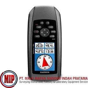
Specifications: Garmin GPSMAP® 78s The Garmin GPSMAP® 78S has a built-in 3-axis tilt-compensated electronic compass and a barometric altimeter. Plus, you can share your waypoints, tracks, routes and geocaches wirelessly with other compatible device users. Receiver Channels: 12. GPS Antenna: High Sensitivity. WAAS Capable: Yes. Acquisition Time: 0: 01 - 0: 36. Accuracy: ± 10m. DGPS: 3-5m.. Waterproof Standard: IPX7. Unit Size ( HWD) : 2.6" x 6" x 1.2" . Unit Weight: 7.7 oz. Display Type: Transflective, 65K color TFT. Display Size: 1.6" x 2.2" . Battery: 2 “ AA” batteries ( not included) . Battery Life: 20 hours. Internal Memory: 1.7 GB. Expandability: microSD™ card. Interface: High Speed USB and NMEA 0183. Waypoints: 2, 000. Tracklog Points: 10, 000 points. Routes/ Legs: 200. Basemap: Worldwide. Map Storage: Expandable. Topographic Maps: Mapsource Topo. Marine Maps: Mapsource BlueChart. Area Calculation: Yes. Electronic Compass: Yes. Barometer/ Altimeter: Yes. Calendar: Yes. Audible Alarms: Anchor, Arrival, Clock, Offcourse. Elevation/ Vertical Speed: Yes. Tidal Information: Yes. Wireless Communication: Yes. Camera: No. Celestial Information: Yes.
Tampilkan Lebih Banyak