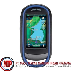
Detail MAGELLAN Explorist 510 GPS Mapping
The eXplorist 510 packs the most accurate maps into the palm of your hand. The World Edition map allows for 2D or 3D viewing angles. It includes a complete road network in United States, Canada, Western Europe, and Australia and major roads throughout the rest of the world and provides cartographic orientation in almost any location. This unique, preloaded map also includes water features, urban and rural land use, and a realistic shaded relief background.
The best of both worlds, the eXplorist 510 combines the user friendliness of a touch screen with the reliability of two customizable hard buttons. Program the hard buttons to your two favorite or most used functions. Powered by two AA batteries, the eXplorist 510 will last up to 16 hours under normal conditions. To help conserve power, use the suspend mode to turn off the device but maintain GPS tracking. You can also adjust power management settings to your preference.
Device
Dimensions ( English) 2.57" x 5.04" x 1.45"
Dimensions ( Metric) 65.3mm x 128mm x 36.8mm
Weight ( English) 6.87oz
Weight ( Metric) 195g
Battery Type 2xAA
Battery Life 15 Hours
Camera Yes
Microphone Yes
Waterproof IPX-7
Speaker Yes
Available User Storage 500 MB
CPU 400MHz
Expandable Memory microSD
Temperature Range ( F) 14F to 140F
Temperature Range ( C) -10C to 60C
Suspend Mode Yes
Internal Memory 2 GB
Screen
Display Resolution, WxH WQVGA, 240 x 400
Screen Size 3.0"
Display Type Color, Transflective
Touch Screen Yes
GPS & Sensors
GPS Accuracy Up to 3-5 meters
High-Sensitivity GPS SiRFstarIII™
Antenna Type Multidirectional Patch
WAAS/ EGNOS/ MSAS Yes
Tampilkan Lebih Banyak